STAC: Transforming Remote Sensing Data Management.
Published on Feb 18, 2024 | Bikesh Bade | 489 Views
What is STAC?
STAC, short for SpatioTemporal Asset Catalog. While it may be perceived as simply another data structure, STAC offers much more than data structure. Introduced in 2021, its popularity has surged, with many leading providers of remote sensing and spatiotemporal data now utilizing the STAC specification. It provides a common structure for describing and cataloging spatiotemporal assets. The STAC specification is a common language to describe geospatial information, so it can more easily be worked with, indexed, and discovered.
Why is STAC getting so popular?
STAC facilitates seamless searching, acquisition, and analysis of geospatial data across various providers and origins. This functionality is crucial as the absence of standardization often results in the limited availability of easily integrable solutions. If you're aiming to construct a resilient backend and effortlessly navigate through data from diverse sources, STAC lays the groundwork for you. STAC was created to facilitate Data providers, Developers, and Data users.
Key advantages of STAC:
1. Well-crafted, standardized format
2. User-centric design
3. Openly searchable and discoverable
4. Easily crawlable and indexable
5. Simple, yet expansible core architecture
STAC Components:
The four key components of STAC include items, catalogs, collections, and the STAC API. These components can be used in isolation from one another, but ideally work best in tandem.
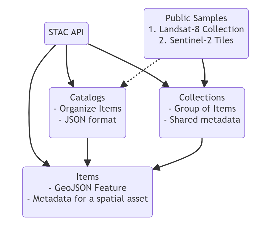
Item
A STAC item is the foundational building block of STAC. It is GeoJSON supplemented with additional metadata that enables clients to traverse through catalogs.
Catalog
A Catalog is usually the starting point for navigating an STAC. A catalog.json file will contain links to some combination of other catalogs, collections, and/or items. This combination is quite variable and flexible depending on how the data is being organized. A catalog may only reference a group of items, it may link to other sub-catalogs and no collections, or a combination of catalogs and collections, etc.
Collection
A STAC Collection builds upon the STAC Catalog specification to include additional metadata about a set of items that exist as part of the collection.
API
This leads us to STAC APIs, the last component of the STAC specification. An STAC API is a RESTful API specification for dynamically querying STAC catalogs. It is designed with a standard set of endpoints for searching catalogs, collections, and items.
Popular STAC provider:
Radiant Earth Foundation is a non-profit organization focused on making Earth imagery and related data more accessible and usable for global development. They provide tools, resources, and a platform for accessing and analyzing geospatial data to address global challenges such as agriculture, disaster response, and environmental monitoring.
2. Microsoft Planetary Computer
The Microsoft Planetary Computer is a cloud-based platform that aggregates petabytes of geospatial data, including satellite imagery, climate data, and more. It aims to facilitate planetary-scale environmental analysis and modeling by providing researchers, scientists, and developers with access to a wealth of data and computing resources.
Google Earth Engine is a cloud-based platform for analyzing geospatial data at scale. It offers a vast archive of satellite imagery and other geospatial datasets, along with a powerful computing environment for processing and analyzing this data. Google Earth Engine is widely used for applications such as monitoring deforestation, mapping land cover change, and assessing environmental trends.
Element84 is a technology consulting firm specializing in geospatial data and analytics. They provide services and solutions for accessing, processing, and analyzing geospatial data, including satellite imagery and remote sensing data. Element84's expertise lies in building custom software solutions, data pipelines, and platforms for a variety of clients and industries.


